
Файл:Kingdom of Prussia 1870.svg

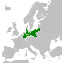
Розмір цього попереднього перегляду PNG для вихідного SVG-файлу: 450 × 456 пікселів. іншы розлишіня: 237 × 240 пікселів | 474 × 480 пікселів | 758 × 768 пікселів | 1011 × 1024 пікселів | 2021 × 2048 пікселів.
Оріґіналный файл (SVG-файл, номінално 450 × 456 пікселів, розмір файлу: 705 КБ)
Попис
Це векторне зображення було створено з допомогою Inkscape .


.svg)
.svg)
.svg)
.svg)
.svg)


.svg)
.svg)
.svg)


.png)
.png)


.svg)


.svg)

.svg)


.svg)
.svg)
.svg)
.svg)


.svg)
.png)


.svg)


.svg)
.svg)


.svg)


.svg)


.svg)
.svg)
.svg)
.svg)
.svg)
.svg)
.svg)
_cropped.svg)
.svg)
.svg)
.svg)
.svg)
.svg)
.svg)
.svg)
.svg)
.svg)
.svg)
.svg)
.svg)
.svg)
.svg)
.svg)
.svg)
.svg)
.svg)
.svg)
.svg)
.svg)
.svg)
.svg)
.svg)
.svg)
.svg)
.svg)
.svg)
.svg)
.svg)
.svg)
.svg)
.svg)
.svg)
.svg)
.svg)
.svg)
.svg)
.svg)
.svg)
.svg)
.svg)
.svg)
.svg)
.svg)
Ліценцованя
Тот файл є доступный під ліценціёв Creative Commons Узнаня авторства-Шыреня за тых самых условій 4.0 Меджінародна.
- Можете слободно:
- здїляти – копіровати, росшырёвати ці передавати дїло
- модіфіковати – адаптовати дїло
- За наступных подмінок:
- узнаня авторства – Мусите увести авторство такым способом, якым то пожадує автор або ліценсор (але не такым способом, котрый бы назначовав, же підпорують вас або ваше схоснованя дїла)
- захованя ліценції – Кідь тото дїло зміните, переведете до іншой подобы або схоснуєте як основу далшого дїла, можете дїло в резултатї шырити лем під тов самов подобов або подобнов ліценціов як є тота.
Історія файлу
Кликнути на датум/час, жебы видїти, як тогды вызерав файл.
| Датум/час | Мініатура | Розмір обєкта | Хоснователь | Коментарь | |
|---|---|---|---|---|---|
| актуална | 04:54, 1 юнія 2016 | | 450 × 456 (705 КБ) | Alphathon | Various corrections to the states of the North German Confederation |
| 07:22, 31 мая 2016 |  | 450 × 456 (662 КБ) | Alphathon | Minor corrections (Tarasp and post-1818 German Confederation border change) | |
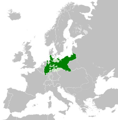
| 04:40, 31 мая 2016 |  | 450 × 456 (662 КБ) | Alphathon | == {{int:filedesc}} == {{Inkscape}} {{Information |Description={{en|A map of the en:Kingdom of Prussia within the North German Confederation and within Europe circa 1870 CE.}} |Source= {{Derived from|Blank_map_of_Europe.svg|display=50}} |Da... |
Хоснованя файлу
Далша сторінка ся одказує на тот файл:
Ґлобалне хоснованя файлу
Тот файл хоснують такы іншы вікі:
- Хоснованя на af.wiktionary.org
- Хоснованя на ar.wikipedia.org
- Хоснованя на bn.wikipedia.org
- Хоснованя на ckb.wikipedia.org
- Хоснованя на en.wikipedia.org
- Хоснованя на eo.wiktionary.org
- Хоснованя на es.wikipedia.org
- Хоснованя на es.wiktionary.org
- Хоснованя на eu.wikipedia.org
- Хоснованя на fa.wikipedia.org
- Хоснованя на fi.wikipedia.org
- Хоснованя на he.wikipedia.org
- Хоснованя на hu.wikipedia.org
- Хоснованя на is.wikipedia.org
- Хоснованя на it.wikipedia.org
- Хоснованя на li.wiktionary.org
- Хоснованя на lld.wikipedia.org
- Хоснованя на lt.wikipedia.org
- Хоснованя на mn.wikipedia.org
- Хоснованя на pl.wikipedia.org
- Хоснованя на ru.wikipedia.org
- Хоснованя на ru.wiktionary.org
- Хоснованя на sk.wikipedia.org
- Хоснованя на szl.wikipedia.org
- Хоснованя на tr.wikipedia.org
- Хоснованя на uk.wikipedia.org
- Хоснованя на uz.wikipedia.org
- Хоснованя на xmf.wikipedia.org
- Хоснованя на zh.wikipedia.org